GPS Photo: With Location & Map
- 4.2
- Rating
- 10.00M
- Installs
- Free
- Price
 Analysis by App-foxy
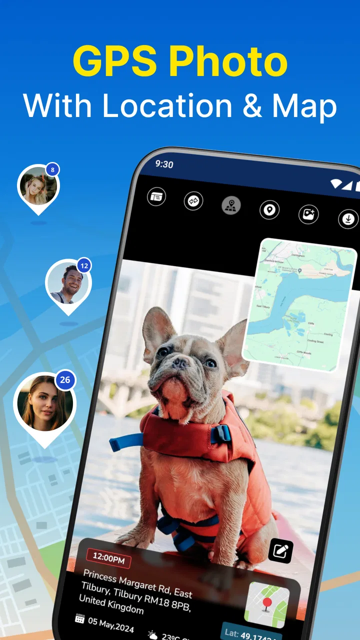
I approached GPS Photo: With Location & Map as a practical travel tool rather than a conventional camera replacement. Its main appeal is the idea of keeping a photograph connected to the place where it was taken, with location, weather, and map context available alongside the image. That makes it interesting for trips, walks, property visits, field notes, and family memories where the picture alone does not tell the whole story.
After using it, my impression is fairly clear: this is most useful when the surrounding context matters as much as the image. If you only want the cleanest possible photo, your phone’s standard camera will usually feel simpler. If you want a visual record that helps you remember where and under what conditions a moment happened, this app has a more focused purpose. I also think its value depends on how comfortable you are reading information layered around a photo, because that extra context can be helpful or visually busy.
How the interface handles location-rich photos
The app sits in the Travel & Local category, and that placement makes sense. It is not trying to be a full photo editor or a navigation replacement. The central workflow is about creating or viewing photos with geographic and environmental details attached. In everyday use, I found that concept easier to understand than a large collection of unrelated camera modes: you take a picture, check the contextual information, and use the result as a memory or record.
You May Also Like

 Blood Strike: 2.5 Anniversary
Blood Strike’s Loadouts Turn Every Drop Into a Tactical Gamble
A close look at Blood Strike’s custom loadouts: how fast access to signature weapons reshapes its battle royale rhythm, rewards preparation, and narrows the gap between fights.

 Pandora - Music & Podcasts
Pandora’s Music Is Easy to Start, but Harder to Recover
Pandora’s strength is its low-effort path from a seed to a station. Its weak spot is how much confidence it asks you to place in connection, setup, and quiet recovery.

 8 Ball Pool
 Is Built on Rivalries, Rematches, and Routine
A close look at the rivalries, rematches, shared routines, and unanswered safety questions that turn a quick pool match into a persistent mobile community.

 Samsung Music
’s Quiet Strength Is Playing What You Already Own
Its reach comes less from spectacle than from dependable access to a personal library. That simplicity is both the app’s strongest retention engine and its ceiling.

 AccuWeather: Weather Radar
AccuWeather Review: A Quick, Clear Forecast for Everyday Decisions
For everyday plans, the best forecast is the one you can understand quickly. AccuWeather makes rain timing, radar, and local conditions easy to act on, with a few trade-offs.

 Hill Climb Racing
Why Hill Climb Racing Still Turns Crashes Into One More Run
A tiny car, a bumpy hill and one more upgrade: Hill Climb Racing keeps resurfacing because its simple chaos makes every near-miss feel personal.
More From Our News Desk
View All News


For someone who benefits from a clear purpose, that narrow focus can be an advantage. You do not need to learn a complicated editing system before getting useful results. A traveler can use it to mark a viewpoint, a walker can document a route stop, and someone visiting several apartments or work sites can create a visual record that is easier to place later. The map element is especially useful when several photos from the same day begin to look alike.
At the same time, information-heavy photos require a little patience. Location labels, weather details, and map elements can compete with the image itself, particularly when you are trying to inspect a small screen quickly. I would not describe the experience as difficult, but I would recommend taking a moment to understand which part of the display is the photo and which part is supporting information. That small pause makes the app feel more manageable.
My practical advice is to decide before taking a picture what you want the final image to do. If the goal is a shareable travel memory, keep the composition simple and leave room for the contextual overlay. If the goal is documentation, prioritize a readable landmark or object instead of trying to create a dramatic photograph. This distinction prevents the app from feeling disappointing when the information panel becomes more prominent than the picture.
Readability for different users and environments
Readability is not only about font size. It is also about contrast, spacing, how many details are presented at once, and whether the user can understand the result without guessing. GPS Photo has a naturally visual workflow, so people who are comfortable interpreting maps and photo overlays will probably adapt quickly. For users with reduced vision, however, the usefulness of the location and weather information may depend heavily on the phone’s own display settings and on the surrounding light.
I found it sensible to review the screen indoors before relying on the app outdoors. Bright sunlight can make map labels and smaller text harder to distinguish, while glare can reduce the practical value of an otherwise informative image. A larger phone may also be more comfortable than a compact one because the map and photo have more room to coexist. These are not special app settings I would assume are available; they are simple choices that can make the overall experience less tiring.
The app is free to install, which makes trying this workflow relatively low-risk. It is rated for Everyone, so its basic audience is broad rather than limited to a specialist travel group. The developer is Galaxy studio apps, and the app has reached over ten million installs with an average rating of 4.1 from roughly eighty-six thousand ratings. Those figures suggest that the concept has found a substantial audience, although popularity does not remove the need to check whether the visual layout suits your own eyes and habits.
One useful habit is to avoid reviewing a photo while rushing between locations. I prefer taking the picture first, then checking the saved result somewhere stable. This reduces the chance of missing a warning, misreading a label, or making a poor decision because the screen is moving or the light is changing. For users who become overwhelmed by dense displays, separating capture from review makes the app feel calmer.
Motor and sensory considerations in real use
Camera apps can be surprisingly demanding for people who have limited hand strength, tremors, or difficulty making precise taps. The challenge is not necessarily the number of controls; it is the need to hold a phone steady, frame a subject, and activate the shutter at the right moment. GPS Photo shares that basic camera challenge. A small movement can change the composition, and reaching across a larger screen may be uncomfortable for some users.
I would use a stable grip, a phone support, or a nearby surface whenever the photo is meant to document something accurately. That is particularly helpful for signs, building details, trail markers, or objects that need to remain readable. A support also makes the app more practical for users who cannot comfortably hold a phone in one position for long. The benefit is not just sharper pictures; it lowers the physical effort required to repeat the task.
For people who are sensitive to visual clutter, the map and contextual information may be more demanding than a plain camera preview. I would treat the app as a documentation tool first and avoid trying to interpret every detail while framing the shot. Capture the important subject, then inspect the supporting information afterward. That workflow reduces sensory load and keeps the main task focused.
Users who rely on hearing should also think about whether they can complete the workflow visually without depending on sound. The app’s purpose is expressed through images, maps, and written context, so I would not choose it on the assumption that audio guidance is central to the experience. In my view, it is better suited to someone who can comfortably inspect the screen or who has another person available to help review a location-heavy photo when necessary.
There is a less obvious trade-off here. Adding context can make a photo more understandable later, but it can also make the immediate capture process less visually simple. For a person who needs a very uncluttered camera interface, a regular camera followed by a separate notes or mapping app may be easier. That alternative creates more steps, yet each step can be more focused and therefore less tiring.
Situational access: travel, work, and everyday memory
The strongest use case I found is a day when many places or conditions need to be remembered. Imagine walking through a new neighborhood during a trip. You photograph a café, a viewpoint, and a street you want to revisit. Later, the map context helps separate those images from one another, while the weather detail brings back something the picture may not show clearly. The app turns a loose camera roll into a more useful travel record.
It can also help in situations where a photo needs an explanation. A person checking a rental property might photograph a room while preserving its location context. A family member could document a garden, landmark, or roadside stop for someone who was not present. A student or hobbyist exploring local places could use the images as a visual diary. In each case, the app is more valuable when the question is “where was this?” rather than simply “does this look good?”
For users who travel with limited connectivity, I would be cautious about planning an entire workflow around live contextual information. I would test the app in the kinds of places I expect to visit before depending on it for important records. Remote areas, underground spaces, dense buildings, and quickly changing travel plans can all make location-based tools less predictable in practice. The sensible approach is to keep the original situation in mind and not treat the app as a substitute for a dedicated navigation method.
That distinction matters for safety. I would not use this app as my only way to find a trail, return to a vehicle, or communicate an emergency location. A photo with a map context may support memory, but it is not the same thing as a purpose-built navigation or emergency service. For serious route planning, I would use an established navigation tool as well and treat GPS Photo as the visual record.
The app also works well for people who remember places visually. Looking at a photograph with location context can be easier than searching a text list of addresses, especially after a busy day. This is one of its more inclusive qualities: it lets the image act as the starting point for recall. Someone who struggles to remember names but recognizes scenes may find that approach more natural.
On the other hand, users who need highly structured text records may prefer a notes app, spreadsheet, or dedicated field-reporting tool. GPS Photo can provide useful context around an image, but it should not automatically be treated as a complete inventory system. If every entry needs custom fields, checklists, signatures, or detailed categorization, another category of app will probably be a better fit.
What may still create friction
The first barrier is the tension between visual simplicity and useful detail. The very information that makes a photo more meaningful can make it harder to scan. I would especially consider this before recommending the app to someone who becomes tired when several visual elements compete for attention. A plain camera has fewer decisions, and a separate map app offers a clearer navigation view. GPS Photo sits between those experiences.
The second barrier is the dependence on the phone as a physical object. Users with limited reach, reduced grip, or difficulty stabilizing a device may need a stand or another person’s help. That is not a flaw unique to this app, but it affects whether the location-rich workflow is genuinely convenient. If taking one steady picture is already difficult, adding contextual review afterward may not feel worthwhile.
A third issue is that weather and location details can create false confidence if they are not checked carefully. I would review the result before sharing it, particularly when the photo is being used to document a place for another person. A map label that looks close enough for a casual memory may not be precise enough for a work decision or a safety-critical situation. The app is best treated as a helpful layer of context, not unquestionable proof.
There is also a privacy consideration in the ordinary sense that location-rich photos reveal more than ordinary images. Before sending a picture to a broad group or posting it publicly, I would inspect what location information is visible. This is a practical sharing habit, not a reason to avoid the app. The more useful the geographic context is for you, the more carefully you should decide who else needs to see it.
The current version is 4.2.0 and requires Android 8.0 or later. That makes the app accessible to many existing Android phones, but anyone using an older device should check compatibility before planning a trip around it. In-app purchases range from $0.99 to $99.99 per item, so although the app itself is free, I would review any purchase prompt carefully and decide whether the extra option is genuinely useful for my workflow before paying.
Compared with a normal camera, this app offers a more informative result but a less minimal one. Compared with a map application, it keeps the photograph at the center instead of treating the map as the primary screen. Compared with a notes app, it is quicker for attaching a sense of place to an image, but likely less flexible for long written records. That comparison helped me understand its proper role: it is a bridge between a camera and a location diary, not a replacement for every tool in either category.
Who I would recommend it to
I would recommend GPS Photo to travelers who want their images to retain a strong sense of place, to people creating visual records of local walks, and to anyone who routinely forgets where a particular photo was taken. It is also worth trying if weather and map context add meaning to your memories. The free entry point makes experimentation easy, and the broad age rating means it can suit family travel and casual personal documentation.
I would be more selective for professional fieldwork. If the record must meet formal reporting requirements, include custom data, or serve as legal evidence, I would choose a specialized tool and perhaps use this app only as a supplementary visual reference. Likewise, if your priority is portrait quality, manual camera control, fast one-handed shooting, or a completely clean frame, your phone’s built-in camera may be the better experience.
For users with visual, motor, or sensory differences, I would suggest a short trial in the exact environment where the app will be used. Test it while standing, sitting, outdoors, and under the lighting you expect. Try a stable support if holding the phone is tiring, and review whether the contextual information is readable without excessive effort. This kind of personal check is more useful than assuming that a broad age rating automatically means every interaction will be comfortable.
My favorite practical workflow is simple: take a deliberate photo, pause before moving on, inspect the location and map context, and only then decide whether the image is worth keeping or sharing. I would also keep a conventional navigation option available for route decisions and avoid publishing location-rich images without checking their visible details. Those small habits make the app more dependable and reduce the main sources of confusion.
My inclusive verdict
GPS Photo: With Location & Map is a focused travel and local discovery app with a useful idea: a photograph can preserve not only what I saw, but also where and under what conditions I saw it. Its best qualities appear when I am building a visual memory or a lightweight location record. The map and weather context give ordinary photos a practical purpose beyond the camera roll.
Its inclusive value is more mixed, but still worthwhile. The straightforward travel focus can help people who prefer visual reminders, while the information-rich presentation may challenge users who need a very uncluttered interface. Physical camera handling, outdoor glare, small details, and location uncertainty are real considerations. I would not promise that it will suit every ability or every environment, but I do think it can be adapted into a comfortable workflow with slower review, a stable phone position, and realistic expectations about what the app is designed to do.
Overall, I see it as a good free experiment for anyone who wants location-aware photos without turning every trip into a formal documentation project. Choose it when the place behind the picture matters as much as the picture itself. Skip it when you need advanced photography controls, structured professional records, or dependable navigation. For the right user, it adds just enough geographic context to make memories easier to understand later without demanding a completely new way to take photos.
FAQs for GPS Photo: With Location & Map
01How does GPS Photo: With Location & Map work?
GPS Photo: With Location & Map integrates seamlessly with your device's GPS to tag photos with precise location data. When you take a picture, the app automatically records the coordinates and embeds them into the image metadata. This allows you to see where the photo was taken on a map within the app.
02Can I edit the location data of a photo in GPS Photo: With Location & Map?
Yes, the app provides an option to manually edit the location data. This is useful if you want to correct the location or add coordinates to photos taken when GPS was unavailable. Simply access the photo in the app and adjust the location using the map interface.
03Is GPS Photo: With Location & Map available for both Android and iOS?
Yes, GPS Photo: With Location & Map is available for both Android and iOS platforms. Users can download the app from the Google Play Store and the Apple App Store, ensuring a wide range of devices can use its features for geotagging photos.
04Does GPS Photo: With Location & Map consume a lot of battery?
The app is designed to be lightweight, but like any GPS-based application, it can consume battery when actively tracking your location. To minimize battery usage, it's recommended to close the app when not in use or adjust the GPS settings in your device to conserve power.
05Can I share photos directly from GPS Photo: With Location & Map?
Yes, the app includes a sharing feature that allows you to share your geotagged photos directly to social media, email, or messaging apps. This makes it easy to showcase your travels and adventures with friends, along with the exact locations where the photos were taken.
Pros
- Easy integration with camera.
- Accurate GPS tagging feature.
- Offline map support available.
- User-friendly interface design.
- Fast photo uploading process.
Cons
- Limited editing tools.
- Occasional GPS inaccuracies.
- Ads can be intrusive.
- Requires internet for full features.
- Lacks cloud backup option.

GPS Photo: With Location & Map
Gallery